Here’s an article from the Summit Daily News, titled “The future of wildfires: A cultural struggle to learn to live with fire”. However, it spends a lot of space discussing how new technology cand transform situational awareness in firefighting. Here’s the interesting part:
Firefighters also are working with new technologies to do their jobs safer and more efficiently. One of the newest tools breaking its way into the firefighting scene is the Android Team Awareness Kit developed by the Air Force Research Laboratory to help track friendly individuals on the ground during airstrikes.
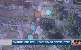
Firefighters in Colorado already have begun using the kit and similar technologies in pilot deployments. The system essentially allows officials to keep track of all of their resources — including firefighters and aircraft — in real time, providing better spatial awareness and allowing individuals to update conditions and threats.
“If I have a safety officer on a hill watching us work, instead of him communicating that there’s a spot beyond some trees to go to if things get bad, he can actually put a point on a map that pops up on everyone’s phone,” said Ben Miller, director at the Colorado Center of Excellence for Advanced Technology Aerial Firefighting. “From the command post where they have the bigger perspective, they can look at lightning or high winds coming in, and they can show us that information within seconds on our map.”
Spatial awareness tools also are helping firefighters implement other military technologies in their practices. The ability for officials to point out detailed locations of power lines and topographical hazards paired with night vision could soon allow helicopter missions after dark.
With operations often in remote areas, firefighters are also experimenting with new equipment that would allow them to detect strong cellular networks nearby and deploy radios to boost the signal to make sure all firefighters are kept in the loop. Similarly, new drone programs are in the works that would allow firefighters to get more eyes on the fire from the air and serve as pseudo-communication satellites.
Down the line, options like Starlink, a satellite internet initiative being developed by SpaceX, would provide firefighters in the backcountry with connectivity independent of cell sites on the ground.
“We want to get to the point where when somebody has something to report, they can just point their camera at it,” Miller said. “And not only would everybody be able to see what they’re talking about, but it could actually triangulate that image so everybody knows what they’re seeing and where exactly it is.”


