C4ISRNET.com has an article on the goTenna Pro-X and ATAK. It also discusses its use by the La Honda CA fire department as well as texas First Responders and there’s a video after the jump.
Here’s an excerpt:
Each goTenna device is a stand-alone tool that can work with other goTenna devices to transmit information through a mesh network. Multiple applications for the mesh network involve showing in real time the locations of people connected to the network, and allowing users to add information, like vehicle icons or plotted paths, onto the maps in a tablet screen.
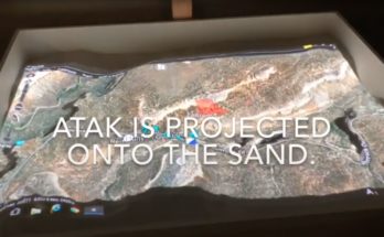
One of the more notable use cases compatible with goTenna Pro and the new goTenna Pro X is Android Team Awareness Kit (ATAK), developed by the government and available off-the-shelf for government users. ATAK is, first and foremost, a kind of “blue force tracker,” allowing users connected through the app to see where everyone is. It’s the kind of situational awareness tool that’s common in video games but harder to replicate in real life. Running ATAK over a mesh network means that the team can still have and share that kind of information even if other, traditional communication infrastructure like cell towers are down.
“We get into these disconnected environments and we have, you know, quite a bit of problems with being disconnected as far as technology perspective,” says Ari Delay, the La Honda, Calif., fire chief. “Our radios typically work, but when we attempt to communicate certain things that are geographic in nature, especially in the early phases of an incident, they’re hard to articulate because we typically don’t have hard copy maps and we don’t have a way to be able to move information back in between forces out in the field.”
Delay first started using goTenna when he purchased the commercial version with his own funds, and since then has found it an invaluable tool in the field. Delay described a fire his team responded to in Alturas, California, in the northeastern part of the state. In an area of zero connectivity, Delay used goTenna to plot routes through forest service roads and then share those routes with his team. That kind of plotting and planning is useful for both getting the right people to the danger, and getting people away from it.


